To succeed in 2026, you must know how to Map Google Maps Coordinates to Excel effectively. This process lets you turn raw numbers into clear, location data that helps you grow your brand.
Many pros use this to organize their geographic information and plan better delivery routes for their teams. When you put your points on a map, you spot trends you might miss in boring rows of text.
If you want to master spatial analysis, you are in the right place. We will show you simple ways to convert coordinates and keep your database clean. It is time to make your business data work for you. Let’s get started.
Understanding Google Maps Coordinates and Excel Integration
What are Google Maps Coordinates?
Google Maps coordinates represent exact physical spots on Earth using two specific numbers called latitude and longitude. Latitude tracks your position north or south of the equator, while longitude tracks your position east or west of the prime meridian.
These two combined numbers function as a unique digital address for any location on our planet, allowing businesses to pinpoint exact assets globally.
Latitude and longitude are standard formats used by global positioning systems. In Google Maps, you can view these as decimal degrees. Understanding how to read these numbers is the first step toward building a database.
When you record these coordinates in Excel, you create a foundation for mapping your own custom business locations or assets. It works. Just numbers.
Why Export or Map Coordinates to Excel?
Moving coordinates into Excel allows you to organize business data, plan delivery routes, and visualize customer locations for your team. You can perform complex calculations, create helpful charts, or filter information to make much better choices.
By integrating location data, you gain the ability to spot trends, compare distances, and manage regional resources with professional precision.
| Benefit | How It Helps Your Business |
| Visualization | Plot customer density on a map |
| Logistics | Calculate travel time between sites |
| Organization | Better Data Hygiene & Segmentation |
| Analysis | Identify new market opportunities |
Method 1: The Manual Approach (Best for Small Datasets)
How to Get Latitude and Longitude from Google Maps
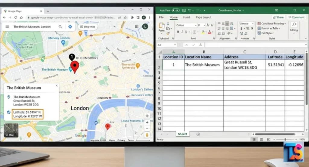
To find coordinates manually, open Google Maps and search for your desired location. Right-click the red pin or the specific spot on the map. A small box appears at the top of the menu with the latitude and longitude numbers.
Click these numbers to copy them, then paste them directly into your Excel spreadsheet.
This method works well if you only need coordinates for a few locations. Once you have copied the data, you can save it into your columns. Always ensure you record both numbers clearly.
If you are working on a small project, this simple copy-and-paste method remains the most accurate way to capture data without any tools. It is easy. Very simple.
Importing Coordinates into Excel
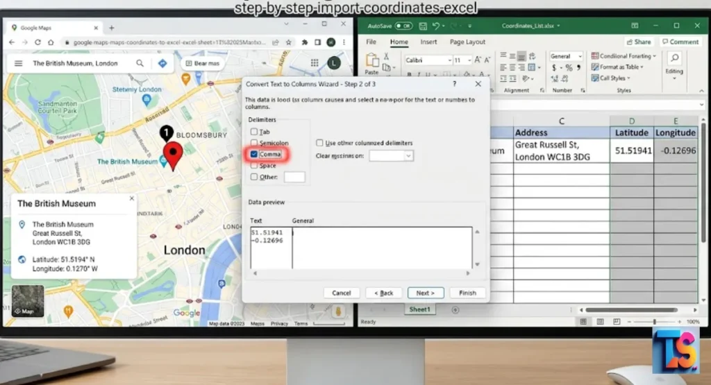
Importing coordinates is a simple process involving pasting your raw data into a specific cell and using the built-in split tools. Excel offers a powerful feature that takes raw data and turns it into clean columns.
This process ensures your location data remains structured and ready for your next project, helping you maintain accuracy across your work without manual typing errors.
- Select the cell or column containing the coordinates.
- Go to the Data tab and click Text to Columns.
- Choose Delimited and click Next.
- Check the Comma box and click Finish.
- Label your new columns Latitude and Longitude clearly.
Converting Addresses to Coordinates Using Geocoding
If you have a list of addresses but lack coordinates, use a web-based geocoding service. Ensure your addresses are complete to improve accuracy. Before finalizing your list, it is wise to Separate Personal and Business Emails in Bulk to ensure your outreach remains targeted.
Once converted, you can download the result as a file and import it directly into your main Excel database for tracking.
Many free geocoders exist online that allow you to process address lists. For best results, ensure your addresses are complete with city and zip code information.
This improves the accuracy of the location data you receive. This step is vital for keeping your location data clean before you attempt to plot it on charts. It helps a lot. Really.
Method 2: Using Professional Scrapers and Extraction Tools
Why Use Third-Party Tools for Bulk Extraction?
Manual extraction is impossible for hundreds of locations. Professional scrapers automate collection, reducing error and saving time. As you curate your databases, you may also want to Filter Competitor Domains from Lead Lists to keep your market intelligence clean and focused.
These tools automate the collection process, significantly reducing human error while saving you hours of repetitive work. This is the standard approach for 2026 data management projects.
Using these tools helps maintain high Data Hygiene & Segmentation. By pulling data directly from the source, you ensure your records remain updated. You can also segment this data immediately, grouping locations by category or distance.
This efficiency allows your team to focus on analyzing the data rather than gathering it from the web. It is fast. So fast.
Key Features to Look for in a Google Maps Scraper
The best scrapers offer more than just data collection; they provide clean, ready-to-use output files. Look for features like category filtering, regional search, and automatic duplicates removal.
A quality tool will save your data in formats like CSV or Excel, making it easy to integrate with your existing workflows without any extra formatting steps.
- Automatic removal of duplicate business entries.
- Filtering by category, rating, or specific location.
- Built-in support for proxy settings to keep your account safe.
- Real-time updates to match the current Google Maps interface.
- Options to export data directly into clean Excel or CSV files.
Ethical Scraping: Extracting Data in Compliance with GDPR
Always act responsibly when scraping data from the internet. Focus only on publicly available business information and respect the rules set by the website you are visiting.
By following standard privacy laws, you protect your company from legal risks and ensure your data collection practices remain professional, sustainable, and reliable for long-term business growth.
Always review the terms of service of the tools you use. Many modern scrapers built in 2026 include safety protocols to keep your activity anonymous and compliant.
By prioritizing ethical methods, you build a foundation of trust. Keep your data collection activities transparent and avoid harvesting personal or private information that is not intended for public use. Follow rules. Stay safe.
Method 3: Advanced Automation via Google Maps API
When to Use the Google Maps API
The API is the gold standard for businesses requiring real-time, automated data feeds. Once integrated, you can even Check Active WhatsApp Numbers in Bulk to streamline your communication efforts alongside your logistics planning.
It provides a direct link to Google, ensuring your data is always fresh, accurate, and ready for high-level business analysis without manual sheets updates.
This method is perfect for developers or anyone comfortable with technical setups. While it requires an initial configuration, the long-term benefits include faster processing and higher reliability.
It is the gold standard for enterprise projects where accuracy and real-time updates are required to maintain a competitive advantage in your specific industry. It is powerful. Very strong.
Overview of Relevant APIs for Coordinate Mapping
Google offers specific tools that handle different parts of your data needs. The Geocoding API turns addresses into coordinates, while the Places API finds specific businesses.
The Distance Matrix API is excellent for logistics, as it calculates exact travel times between locations. Combining these APIs allows you to build a powerful, automated data system.
- Geocoding API: Converts addresses to latitude and longitude.
- Places API: Retrieves business details and location data.
- Distance Matrix API: Calculates travel time and distance for routing.
- Elevation API: Provides height data for specific coordinates.
Technical Requirements and Considerations
To start, you must create a Google Cloud account and generate an API key. You will need to manage your billing and monitor your usage limits in the dashboard.
Be mindful of request quotas to keep your costs predictable. Proper planning of your API calls ensures your system stays active and efficient all year long.
- Set up a project in the Google Cloud Console.
- Enable the specific APIs needed for your mapping task.
- Generate and secure your unique API key.
- Configure billing alerts to monitor your monthly usage.
- Test your calls with a small dataset to verify accuracy.
Advanced Techniques: Transforming Your Data
Bulk Geocoding Missing Coordinates in Excel
When your spreadsheet has missing location data, you can use Excel add-ins to fill the gaps. These small programs connect your sheet to a geocoding service.
You simply select your list of addresses, click the plugin button, and the service fills your latitude and longitude columns. It is a fast way to complete your data.
This process is a key part of maintaining good Data Hygiene & Segmentation. By ensuring every address has a coordinate, you make your dataset much more useful.
It allows you to use advanced features like 3D mapping and distance analysis. Always verify the results after the process to ensure every location is mapped with high precision. Check your work. Now.
Connecting Excel Addresses to Interactive Google Maps
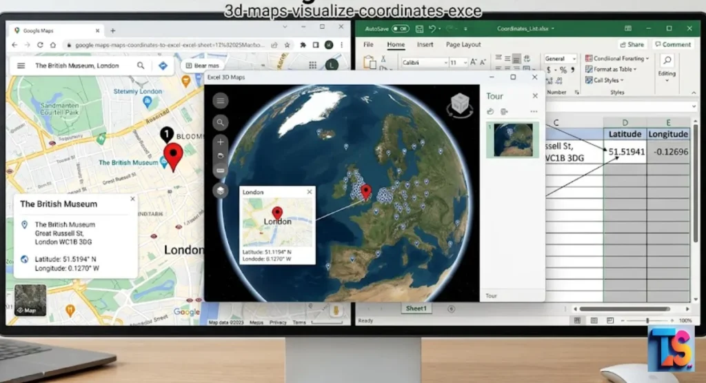
Excel includes a powerful tool called 3D Maps that makes your data visual. After you have your latitude and longitude, go to the Insert tab and click 3D Maps.
Excel creates an interactive globe where you can see your data points. This is excellent for presentations or finding geographic patterns that are hidden in rows.
This tool helps you see your market like never before. You can adjust the height of bars to represent sales volume or use heat maps to show high-activity areas.
Using these visual tools makes your data more impactful for your team, turning complex spreadsheets into clear, easy-to-understand maps that highlight exactly where your business is growing. It is cool. Really cool.
Creating a Distance Matrix for Logistics and Planning
A distance matrix allows you to compare many locations to find the most efficient travel paths. By using Excel formulas paired with the Google Distance Matrix API, you can see the travel time between your warehouse and all your delivery points.
This helps you save on fuel, reduce travel time, and serve your customers faster.
This practice is essential for logistics planning in 2026. By calculating the most efficient routes, you lower your operational costs and increase productivity. Start by listing your origin point and your destinations.
Use the API to pull the data into Excel, and then use your spreadsheet to identify the best sequences for your daily delivery drivers. It works well. So well.
Best Practices for Managing Geographical Data in Excel
Data Cleaning and Formatting Tips
Before you map your data, it must be clean and organized. Remove any duplicate rows, fix spelling errors in addresses, and use the Trim function to delete extra spaces.
Standardizing your address format ensures that your geocoding tools work correctly every time. Clean data leads to fewer errors and more accurate results for your business maps.
| Step | Action | Why It Matters |
| De-duping | Remove repeat entries | Prevents map clutter |
| Trimming | Remove extra spaces | Ensures search accuracy |
| Standardizing | Fix spelling and state formats | Improves Data Hygiene & Segmentation |
| Formatting | Use consistent labels | Makes analysis easier |
Ensuring Coordinate Accuracy and Datum Standards
Most digital maps use the WGS 84 system. Always confirm your Excel coordinates match this standard. If you combine data from multiple sources, double-check that they all use the same system to prevent location drift.
Accurate coordinates are the backbone of your project, so verifying this standard helps you avoid mapping points in the wrong spots.
You should always verify your data source settings before you begin. If you mix systems, your points will appear in the wrong places on your map, which ruins your analysis.
By setting a single standard like WGS 84 at the start, you keep your geographical data clean, consistent, and ready for professional use. Check the map. Do it.
Managing Large Datasets Without Performance Loss
Working with thousands of rows can slow down your computer. To keep things fast, convert your range of data into an official Excel Table. This allows for faster calculations.
For very large files, save your workbook as a binary file to reduce the size and improve the speed of your work every single time you open it.
Using tables helps your software manage the data more efficiently. When you use binary formats, the file size shrinks, which makes the whole spreadsheet run much faster.
If you want to maintain top-tier Data Hygiene & Segmentation with massive lists, using these simple formatting tricks is the best way to keep your system performing well. Speed is key. Always.
FAQs
Can I export unlimited Google Maps leads to Excel?
While many tools are available, always follow the rules set by Google regarding data usage. Excessive scraping can lead to account restrictions. For high-volume needs, the official Google Maps API is the best and safest choice, as it is built for scaling and gives you reliable, long-term access to the data you need for your business.
Is it possible to convert UTM coordinates to Latitude and Longitude in Excel?
Yes, you can convert UTM to latitude and longitude using custom formulas or helpful scripts. You must know your specific UTM zone and datum. Many free, open-source templates are available that provide the conversion math needed to do this directly in your spreadsheet. Once you add the formulas, the conversion happens automatically for every row. It is easy. Really.
Do I need coding skills to map coordinates to Excel?
You do not need to be a programmer for most mapping tasks. Many tools, browser extensions, and built-in features allow you to get the results you need with just a few clicks. Coding is only necessary if you choose to use the advanced API methods to create your own custom, high-speed, and automated data collection pipelines.
What is the most efficient method for bulk coordinate conversion?
The most efficient way to convert bulk data is using a dedicated geocoding API or a professional service. These tools are designed to process thousands of addresses in just a few minutes. They offer high accuracy and provide structured, clean data that is ready for immediate use in your Excel models and planning charts.
The Bottom Line
That mapping your data brings real power to your business. Start small. Learn the steps. Soon you will see your data in a brand new way. Use these tips to stay ahead.